According to this article from the June 11, 1913 edition of the Nevada State Journal (Reno, NV), a 250-mile stretch of the future US-23, between Bay City and Mackinaw City, was built in ONE day by the hardworking citizens of Northeastern Michigan.
EIGHT THOUSAND JOIN IN ROAD WORK
Alpena, Mich., June 10. --
Eight thousand business and professional men and farmers in Northeastern Michigan made road laborers of themselves and constructed more than 250 miles of roadway between Bay City and Mackinaw City. Where there had been at sunrise mile after mile of corduroy road, sand holes and swamps [by] night fall found an almost unbroken stretch of leveled highway. The new roadway forms a part of the state highway from Detroit to Mackinaw City. The stretch built yesterday passes through 48 townships. Four thousand teams and 750 automobiles participated in the great bee. The women of the country also did their share of the work, 500 of them being engaged in the task of feeding the workers along the route.
From the modern perspective, it's pretty mind-blowing to think about - every man between Bay City and Mackinaw City voluntarily sacrificing an entire day to accomplish such a big task. Can you imagine what we could accomplish today if we were all willing to donate our time and work together for just one day?
Friday, October 8, 2010
In the News... Built in a Day
Friday, October 1, 2010
Maps, Maps, Maps!
Part of the fun of history and genealogy, for me anyway, is imagining what life was like for my ancestors and those around them. The census records, death certificates, and other written evidence of our ancestor's lives are great - but I like to have something a little more tangible. So I've gotten into the habit of creating custom Google Maps (marking locations of people and places on a real satellite image) to see the big picture of the world our ancestors lived in. Who were their neighbors? What did their land look like? Where did they attend church and school?
I've already posted a map of the Metz Fire of 1908, which can be found a few posts down.
Another project that is very near completion and has been quite an undertaking, is the schools, churches, cemeteries, post offices, stores, and more of Presque Isle County as found on the 1903 Plat Map.
View Presque Isle County in 1903 in a larger map
The ladies from the Presque Isle GenWeb website, who have contributed so much to the project, went around taking photos of many of the sites on the map so I could add them. A photo will pop up for many of the schools, churches, and cemeteries you click on. A huge thank you goes out to BJ and Janet who helped with this!
Another project I'm just starting which is sure to be a long time coming is actually platting out all of Presque Isle and Alpena Counties - recreating the property lines of 1903 and placing markers on the exact location of the homes. So far, only Sections 1 - 12 of Belknap Township, Presque Isle are complete. Please check back periodically for new additions. On the sidebar to the left, residents are arranged by section, and if you click on a name it will take you to their home on the map. The map works best at about 2/3 of the way zoomed in.
View 1903 Belknap Twp Homesteads in a larger map
If you want to find out where your ancestor lived, but it's not on the map yet, check out Historic MapWorks which has an amazingly good zoomable scan of the 1903 Alpena, Presque Isle, and Montmorency Plat Book I'm working from. Please leave a comment if you have any questions, corrections, or want to find out where your ancestor lived. I'd be glad to help!
Tuesday, September 28, 2010
Presque Isle Co - 1918 Death Records Transcribed!
If you check out my post from last week with the records from Alpena, you'll see what I'm trying to accomplish here by transcribing the 1918 death records for Alpena and Presque Isle Counties...for now I'll avoid repeating myself!
To see the database of 148 death certificates for PI County from 1918, please go here. I extracted a lot of good data like first/last/maiden name, death date, age, name of parents, and cause of death, but to see the whole certificate and additional info, visit Seeking Michigan and search. Death certificates are available from 1897-1920.
Here are the stats for Presque Isle County, during the year of the infamous influenza epidemic:
Total Deaths - 148
Accidental - 4 (3%)
Cancer - 5 (3%) *today cancer accounts for over 20% of deaths in the US
Heart Disease - 13 (9%) *today, heart disease accounts for nearly 25% of US deaths
Influenza - 25 (17%) *much lower than Alpena/national averages which were around 35%
Other Diseases (Scarlet Fever, Typhoid Fever, Cholera, Meningitis, etc) - 15 (10%)
Tuberculosis - 12 (8%)
Suicide - 2
Infants - 51 (34%)
In comparing these numbers to those of Alpena County, a few things stand out. First, the dramatically lower number of influenza-related deaths. Could this be because of the lower population density and fewer outside visitors? Perhaps. It could also be that, in the more rural Presque Isle County, fewer deaths were actually reported. One thing I definitely attribute to PI County's much higher rate of infant death is the rural location and lack of medical or sanitary resources nearby.
In the Victorian Age, there was a huge disparity between urban and rural populations, and the difference in available technologies and medical care was great. For example, Alpena and Presque Isle townships didn't even have electricity until the late 1930s, when Alpena Electric Light Company had already been serving Alpena since 1881. Also, very few in the farming community had automobiles at that time, denying them access to McRae Hospital in Alpena. Contrary as it sounds, very few farmers at that time even had horses, which were a luxury. Many farmers could only afford the more practical option of oxen, which could help with farm labor. Unless a qualified medical professional was in walking distance of those in peril, they were usually on their own, in a time when there was no internet, virtually no farmers had a secondary education, and very little medical information was available to the rural public.
Friday, September 17, 2010
Interactive Metz Fire Map
View Metz Fire in a larger map
With the 102nd anniversary of the Metz Fire coming up on October 15, I decided to create a Google Map for those interested in the subject. The map paints a picture of the events of that day and the widespread destruction caused by the fire. Included are the site of the train car disaster, the depot, homes of those killed in the fire, cemeteries where victims are buried, and more. Photos are included where available and relevant.
To use the map, find the area you're interested in and zoom in, or just click one of the icons. Information, and a picture if available, will pop up for that site, like this.

If you have something to add to the map, or a correction, please let me know and I'll be glad to include your suggestions!
Monday, July 12, 2010
Maritime Monday: The Fate of the FAME
In the book "My Recollections of Early Grand Lake," George H. Kauffman tells the tale of how his grandfather (and most well-known pioneer of Presque Isle Township) John Kauffman sailed from Germany at the age of 14 for the United States. Once arriving in Detroit, he got work on a bark called the FAME, and the ship headed north on Lake Huron. The year was 1854.
A storm hit, and upon rounding the point at the Old Presque Isle Lighthouse, the ship capsized and John floated ashore near one of the only structures in the area, a long wooden dock owned by Frederick Burnham. As the old story goes, though he escaped with his life, all of his money and possessions were lost in the wreck. With no money to continue his journey, he decided to stay put where he was and earn money bringing lumber down to Burnham's dock, where steamers would stop and pick up wood for fuel. John would settle in the area and remain there for the rest of his life, other than his time of service in the Civil War.
Fast forward to 1887. After escaping a series of over 10 other accidents, a ship called FAME flounders and is driven ashore at the Old Lighthouse. Finally incapable of sailing again, the ship is disassembled and her timbers are incorporated into the Old Lighthouse Keeper's House as well as rumored other structures.
Could this be the same FAME that had almost met her doom at this same place 33 years earlier? I believe so. According to the stats found at boatnerd.com, the FAME that wrecked in 1887 was built in 1853, one year before John Kauffman was shipwrecked. This accident is not, however, mentioned in the long list of close calls found on the site:
Lengthened 24 feet over the winter of 1853-4.
Stranded at Goderich, Ont, in Oct, 1854 and pulled off the following spring.
Stranded at Thunder Bay, MI in May, 1856
Struck by lightning in June of 1856 while all of her crew were trying to take in sail. All 10 injured, some seriously.
Collided with the bark SUNSHINE in Nov, 1856, on Lake Erie, with significant damage.
Collided with another vessel in Chicago harbor in 1857 with significant damage.
Capsized in a squall on August 17, 1858, 6 miles off Monroe, MI, Lake Erie. Her crew were rescued, but the owner’s nine-year old son floated off into the night on a plank. He was finally picked up 70 hours later, alive but suffering from exposure. Out of Sandusky, OH, at that time, owned by William Blosier.
Ashore at Eagle Harbor. Lake Superior, in August of 1863, and struck by lightning while being towed back to her homeport, Detroit. Owned by E.W. Hudson.
Sunk in a collision near Chicago in November, 1865.
Ashore on S. Manitou in May of 1866 with heavy damage. At least three other damaging accidents including a collision during 1866.
Damaged in a collision on Lake Huon in Sep, 1867.
Rerigged as a lumber barge in 1871.
Sprang a leak and sank at Sand Beach, MI, in 1885
As many as three other accidents.
Sources: mv,slh,nsp,letter,lhdc,hgl,usls,ledc
It seems very plausible that the "John Kauffman incident" could easily be one of those in the "as many as three other accidents" category. If one believes in such things as fate, this is certainly a stunning example. A ship which should have sunk in 1854 fights its doom - surviving accident after accident until it ends up in the same place it should have been in the first place - 33 years later.
A great man (well, boy at the time) traveling around aimlessly, finds his destiny when he is stranded alone in a place with next to no people and nothing but trees around him. And anyone who knows the history of Grand Lake knows it was his destiny - it is hard to imagine a history without John Kauffman in it.
The timbers of this ill-fated ship end up in the Old Lighthouse, which seems to be where they belonged. They became a part of the very fabric of the place, just as John was a huge part of the community. This beautiful "false island" seems to be where they were both destined to remain, and they did.
I have yet to verify if these two FAMEs were indeed the same ship - I've heard Bill Lewis is "the authority on all things FAME" so perhaps he has some conclusive evidence.
Hope you enjoyed the forever-intertwined tales of a man, a boat, and the place they both eventually called home.
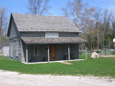
John Kauffman Homestead

Friday, July 9, 2010
Our Civil War Heroes - Presque Isle
Because the lists are so long, I decided to create two separate posts for our area Civil War Soldiers. Here are the veterans from Presque Isle County.
PRESQUE ISLE COUNTY -
Presque Isle Township
John H Fulton, William Isaacs, Albert Edwin Dynehart, David Rowell,Henry Lee, Dorithe Gauthier, John Westrope, John Kauffman, John Millholand
John Fulton suffered gunshot wounds to the neck and shoulder, was completely deaf in his right ear, and was imprisoned in the notorious Libby Prison for over 5 months. William Isaacs was shot in the thigh and was completely deaf in both ears. David Rowell was shot in the thigh and was a prisoner for 3 months.
Allis Township
Joseph P Wickershaw, Robert Jones, Jarvis B Smith, John M O Smith, Charles H Johnson (widow pensioner Elnora), Royal J Taylor, Hiram J Hodges, Isaac VanHorn
Joseph Wickershaw suffered an injury to his left breast. John Smith contracted impaired hearing and rheumatism, Royal Taylor had "falling" of the mumps, and Isaac VanHorn had chronic diarrhea (often a permanent complication of diseases contracted during the war)
Belknap Township
Eli Crackett (widow of),? Sack (widow of), Henry Jacobs, William Schlaeger, and Christopher Adrian
Eli was shot through the right leg and discharged on surgeon's certificate. Henry had multiple (but unfortunately illegible) injuries, and William Schlaeger was shot in the left leg. Christopher Adrian had a back injury.
Case Township
Joseph F McNall or McFall, John Caldwell, and Ernest B Schmidt
Ernest Schmidt was receiving a pension of $16 per month because he was wounded by cars (train cars?) wrecked while in US service. "Shoulder broke and otherwise hurt."
Moltke Township
James Fitch, uninjured
Rogers Township
Paul Carnwin, Captain/2nd Lieutenant, Henry Platts, Corporal, William H Kitchen, Sergeant, David J Canant, John Bruning, Horse Farrier, William Dueltgen, Musician, Harvey L Parris, Sergeant, Robert H Pelo? (widow of), and William Hunter
Bruning and Parris were both discharged on general disability.
Metz, Bearinger, Posen, and Bismarck are missing from the census, though another list I found lists William Rose - Bismarck, Charles Meyers - Metz, Louis White - Posen, and Henry C Fuller - Bearinger.
Follow Friday: Seeking Michigan
***"Follow Friday" is a theme where the blogger posts about another blog, website, or other resource that may be valuable to other readers of their blog.
Today, I'd like to share a wonderful source of information for those interested in Michigan history and genealogy. The government-sponsored website is called Seeking Michigan and contains millions of documents and photos chronicling our state's rich past.
Perhaps the resource most useful to genealogists is the large collection of millions of death records from the years 1897-1920. These are actual images of the death certificates themselves, which are a wealth of information such as birth date, death date, name of parents, cause of death, place of burial, and more. Doing a general search can be a bit tricky but the "advanced search" tool is very helpful.
Also useful to genealogists are enlistment records, manuscripts, and photos of Michigan Civil War soldiers. I have yet to explore these, but the images look great. There are also early photos, maps, and WPA (New Deal Program) Property Details.
Great resources for those interested in Michigan's history are oral histories, early documents, a collection of 400 pieces of sheet music by Michigan composers, information and photos of the Governors of Michigan, architectural sketches and photos,photos and postcards of the Lighthouses and Lifesaving Stations of Michigan, and a "Main Streets" postcard collection featuring postcard images of Michigan's downtown areas.
There are several pages worth of printable historic photos and postcards from our area lighthouses available.
Or, if you're feeling nostalgic, check out the "Look" section which has pleasant pictures and stories of days gone by by the archivists of the State of Michigan. (That will be me someday!)
I hope you have as much fun exploring this site as I do! Happy Friday all!


Thursday, July 8, 2010
The Resort Days
Our area is well-known as a tourist destination, and many of our outlying areas and lakes were exclusively resort areas long before permanent, year-round, settlement. Here are some postcards of the early resorts of our area. Some of them are long gone and forgotten, and some are still around.
ADRIAN RESORT HOTEL - Long Lake
Doesn't this place look grand? I can find no mention of this place in any of my books or online. There are no Adrian property owners along Long Lake in the 1903 Plat Book. Since this photo was taken in summer 1908, I can only guess that Mr. Adrian dumped his life savings and months of back breaking labor on this beautiful place, just in time for it to be destroyed by the Metz Fire a few months later in October.
BIRCH HILL HOTEL - Grand Lake
This hotel was built in the late 1890s and opened in 1901, owned and built by Joe Kauffman, brother of George F Kauffman who built the Fireside Inn. It was in operation until the 1960s. I'm not sure of the exact location on Birch Hill though I would assume it's on the site of the current Birch Hill Resort.
FIRESIDE INN - Grand Lake
This resort was built by George F Kauffman in 1908, at the pleading of his wife who had saved up $350 to build it. He was at first reluctant because his brother Joe already owned the Birch Hill Hotel and he did not want to compete with him, but eventually he caved in. They used their $350 along with the unlimited free timber around them and their own labor to complete the hotel. This resort is still in operation today, and I worked there every summer during my high school years.
PRESQUE ISLE LODGE - Grand Lake
This hotel was built in 1920 by Newell A Eddy, Jr - partially as a place to showcase the family's handmade furniture which fills the Lodge today. It was the 4th resort to be erected at Grand Lake. Despite being closed for a number of years, the resort re-opened several years ago and is a very popular inn for tourists and event venue for locals.
Two other resorts I can't find much information or any photos on are the Grand Lake Hotel and the Colony Bar. The Grand Lake Hotel was owned by Bliss Stebbins, and was eventually split up, then converted into a private residence. I know nothing of the Colony Bar other than it was one of the 4 original resorts on Grand Lake.

Treasure Box Thursday: Metz Fire Newspaper
Yesterday, while surfing eBay for old objects from our area, I came across this October 16, 1908 edition of the Fitchburg Daily News in Massachusetts. It's a real, over 100 year old newspaper from across the country, and the devastation that had hit our area was the main story. This would be a great add to someone's treasure box!

Wednesday, July 7, 2010
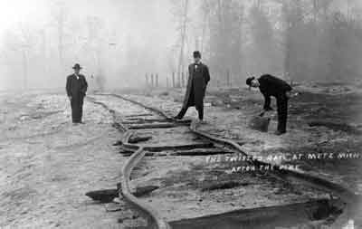
Wordless Wednesday: Twisted Tracks
If you live in the area, there's a good chance you know what happened at this site. Share your thoughts!
Tuesday, June 29, 2010
Using Maps to Paint a Picture
One of the things I've been doing to better visualize what our area used to look like is using the 1903 Plat book and current day Google Maps to find where the homes/schools/post offices, etc of the day were on a modern day map. It helps to paint a picture of which people were neighbors, which landmarks they lived near, and where they would have gone to school and conducted business.
This week, in my Bell frenzy, I started a map showing what Presque Isle Township looked like in 1903. I will publish the link when I have more done, but here's the basic idea:
The colored rectangles are the acreage owned by the residents and the house icons are their homes. When you click on an icon, the description will pop up - the Bell School is selected for example. Upon zooming in, you get very detailed aerial shots and are able to see the exact locations of homes, outlines of old roads, and clearings where buildings used to stand. This tool has proven most useful in providing me with a picture of what the community was like over 100 years ago.
I'm also working on a broader map of Presque Isle County which includes churches, cemeteries, schools, lumber mills, and other landmarks. The focus of this one is more on landmarks and less on land ownership because it is so big. The map does however include photos of almost every schoolhouse, church, and cemetery left standing among other landmarks, thanks to BJ over at Presque Isle County GenWeb who is taking photos for me in my absence. I hope someday to plat out the entire county. 
The process of creating these maps can be tedious and time-consuming, but it's well worth it to me because it makes it easier for us to relate to the people and places of the past when we're able to compare them against modern-day landmarks.
The Village of Bell: As if it Never Existed
Many people in our area have heard of, or visited, Besser Natural Area off of Grand Lake Road in Presque Isle Township. Jesse Besser bestowed this land to the public in 1966 because it was the only virgin pine stand in the area that had not either been cut down in the old logging days or destroyed by the Metz Fire of 1908.
Most people know there is a trail, the old road that used to loop around the small peninsula at the edge of the bay, which is a popular destination for tourists and locals alike. Along the trail are a few reminders of civilization including a lonely stone chimney, a sign, and other scattered debris.
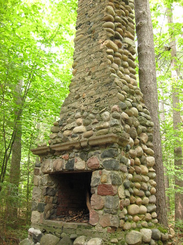
There is also a cemetery, with only one remaining original grave, which was lovingly restored in the 1980s and given fences and one stone with the names of some of those known to be buried there. I am currently working with the current keeper of Presque Isle Township history to provide her the dates of death of these people and find the unknown burials. More about that later!
It is a very common misconception that the village of Bell existed entirely within the Besser Natural Area. That couldn't be further from the truth, as I discovered this week. In comparing the 1903 Plat Map against a current-day aerial Google Map, I found that most of Bell was actually found along the stretch of Grand Lake Road between the Township Hall and the Hide-a-way! The school, the post office, and most of Bell's known residents can all be found along that stretch of road. This is great news, because it means there's actually a lot more left of Bell than we realized. It means that those who built the historic farms along the road were citizens of Bell, and some of their homes are still intact!
When I decided to do something to find out more about these lost residents and the logging town they called home, I was very surprised and disheartened to find out that there is only a very small amount of information available on the topic. It has become clear that many people are interested in knowing more about the lost village of Bell, and I am very excited to participate in helping find and share information with the public.
Look for many more posts on Bell and the people who once called it home. I'm currently pouring a lot of my energy into the subject and will be posting my findings here. Follow me and be the first to know when new info is available!


